Addingdding New Mapping Software to your StreetPilotNew Mapping Software to your StreetPilot
You can purchase additional MapSource mapping software from Garmin such as City Navigator EuropeYou can purchase additional MapSource mapping software from Garmin such as City Navigator Europe
or MetroGuide Canada. Information from these maps will appear on the StreetPilot’sMap page just like theor MetroGuide Canada. Information from these maps will appear on the StreetPilot’s Map page just like the
City Navigator maps you initially installed in your unit. Follow the instructions that came with your newCity Navigator maps you initially installed in your unit. Follow the instructions that came with your new
mapping software to ensure proper installation of the maps to your computer and StreetPilot.mapping software to ensure proper installation of the maps to your computer and StreetPilot.
Controlling MapViews on the Map PageControlling Map Views on the Map Page
You can view a list of your maps, which includes the City Navigator maps you originally installedYou can view a list of your maps, which includes the City Navigator maps you originally installed
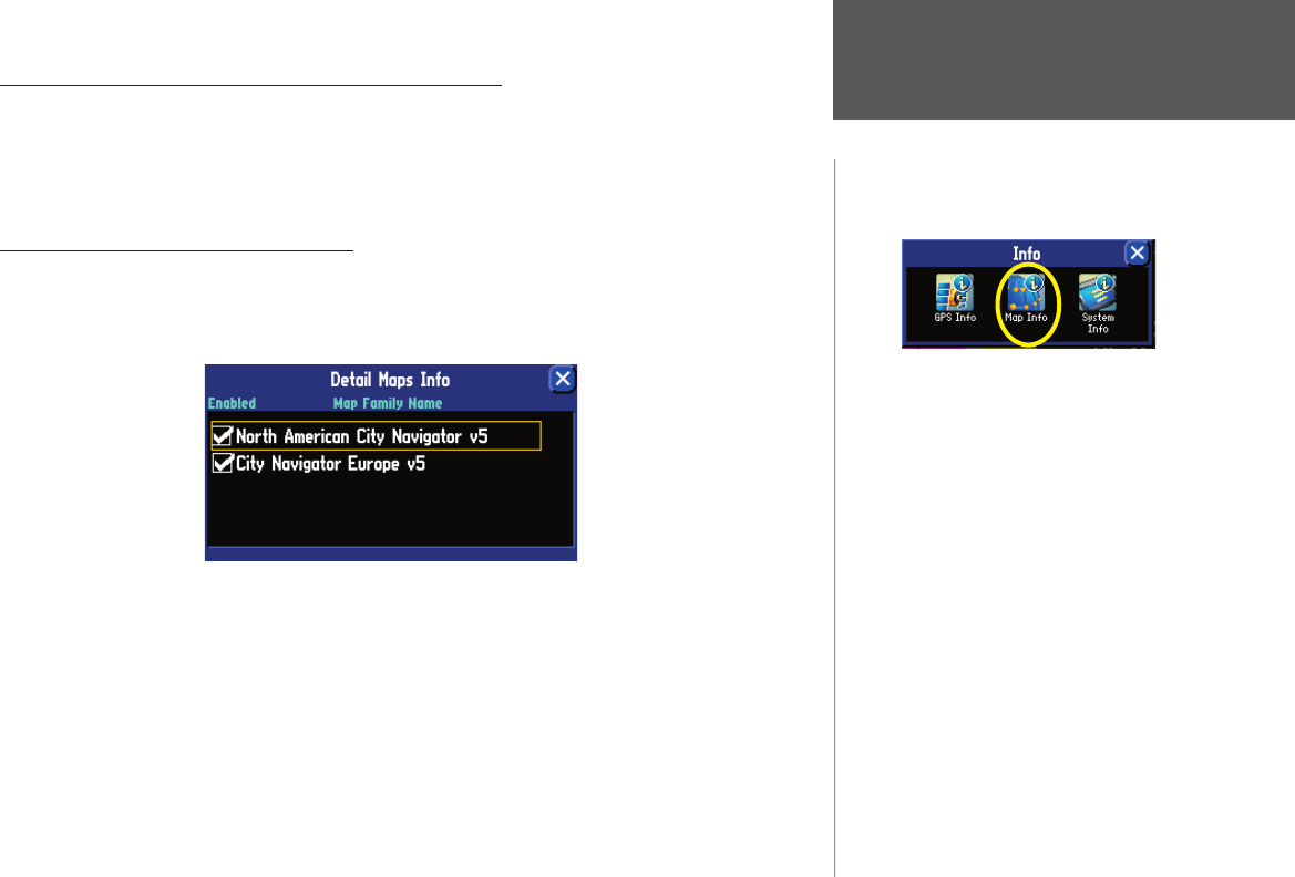
as well as ones you have recently added, on theas well as ones you have recently added, on the Detail Maps InfoDetail Maps Info page. To access this page, press the page. To access this page, press the
StreetPilotStreetPilot MENUMENU key two times; an key two times; an InfoInfo page appears. Touch the page appears. Touch the Map InfoMap Info icon and the icon and the Detail Maps InfoDetail Maps Info
page appears:page appears:
In the example above, the StreetPilot owner has downloaded numerous map fi les from North American
City Navigator v5 as well as from City Navigator Europe v5. A box appears to the immediate left of each
Map Family Name (directly under Enabled). When the Enabled box is checked, your StreetPilot will draw
the map data from these maps to your StreetPilot. To disable a map, uncheck the box by touching the map
name. If the maps loaded in your StreetPilot do not overlap, you should not need to disable maps. If you
load two maps that cover the same area, however, you may want to disable one of the maps so that you
can view detail from the other one.
Access the Info page pressing the unit’s MENU key
two times. Select the Map Info icon to access the Detail
Libble nimmt den Missbrauch seiner Dienste sehr ernst. Wir setzen uns dafür ein, derartige Missbrauchsfälle gemäß den Gesetzen Ihres Heimatlandes zu behandeln. Wenn Sie eine Meldung übermitteln, überprüfen wir Ihre Informationen und ergreifen entsprechende Maßnahmen. Wir melden uns nur dann wieder bei Ihnen, wenn wir weitere Einzelheiten wissen müssen oder weitere Informationen für Sie haben.
Art des Missbrauchs:
Forenregeln
Um zu sinnvolle Fragen zu kommen halten Sie sich bitte an folgende Spielregeln:
Lesen Sie zuerst die Anleitung;
Schauen Sie nach, ob die Frage bereits gestellt wurde;
Stellen Sie die Frage so deutlich wie nur einigermaßen möglich;
Erwähnen Sie was Sie bereits versucht haben um das Problem zu lösen;
Ist Ihr Problem von einem Besucher gelöst dann lassen Sie ihn / sie wissen in diesem Forum;
Falls Sie reagieren möchten, so verwenden Sie bitte das Antworten- Formular;
Da ihre Frage für alle Besucher sichtbar ist, sollten Sie lieber keine persönliche Daten erwähnen.
Neu registrieren
Registrieren auf E - Mails für Garmin streetpilot 2610 wenn:
neue Frage gestellt werden
neue Handbücher vorhanden sind
Sie erhalten eine E-Mail, um sich für eine oder beide Optionen anzumelden.
Das Handbuch wird per E-Mail gesendet. Überprüfen Sie ihre E-Mail.
Wenn Sie innerhalb von 15 Minuten keine E-Mail mit dem Handbuch erhalten haben, kann es sein, dass Sie eine falsche E-Mail-Adresse eingegeben haben oder dass Ihr ISP eine maximale Größe eingestellt hat, um E-Mails zu erhalten, die kleiner als die Größe des Handbuchs sind.
Ihre Frage wurde zu diesem Forum hinzugefügt
Möchten Sie eine E-Mail erhalten, wenn neue Antworten und Fragen veröffentlicht werden? Geben Sie bitte Ihre Email-Adresse ein.